 |
www.ernst-christen.ch
Ernst's Velotouren |
| |
| Home |
| Reiseblog |
| Tourenarchiv |
| GPS-Daten |
| Infos & Tipps |
| Presse |
| Bücher |
| Kontakt |
| Radreise & Fern-radler Forum |
ENGLISH SITES |
| Travelblog |
| Route |
| Contact |
|
|
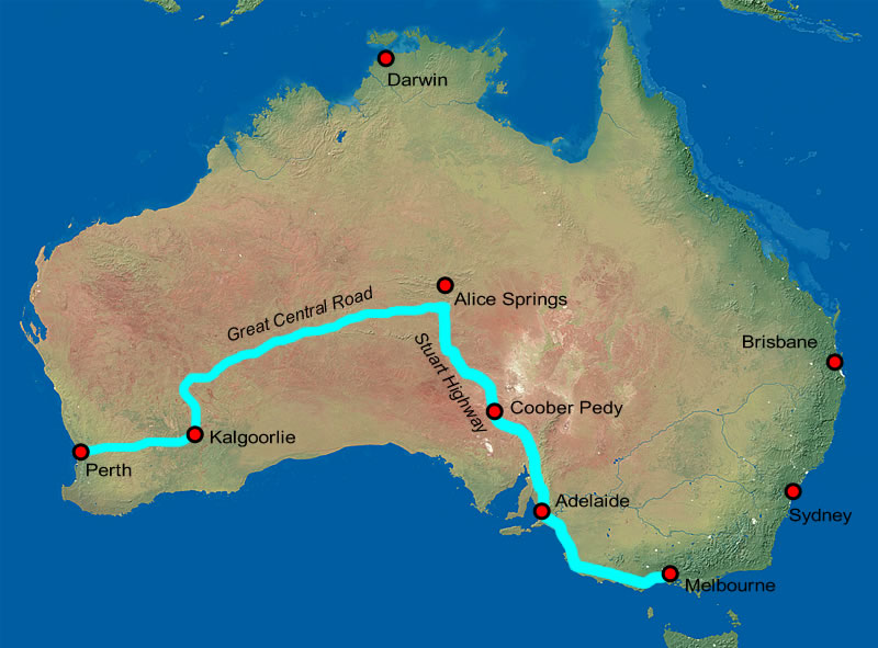
Second stage South East Asia - Australia Part 4: "Great Central Road", Central-Australia |
Download Tour GOOGLE EARTH / GARMIN MAP SOURCE |
 |
| Overview, for details see Google Earth or Garmin-File. |
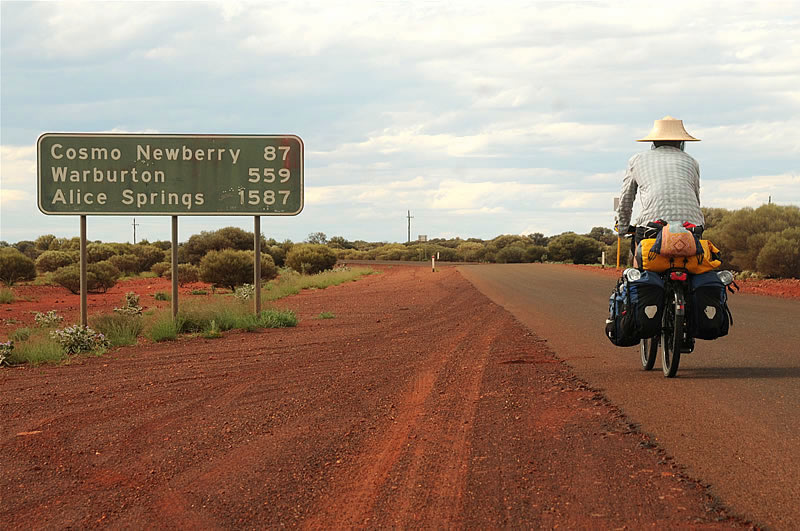 |
| Picture: From Laverton, the start of the "Great Central Road", it is regarding the upcoming Towns very very clear. In detail: Cosmo Newberry 87 km, Warburton 559 km, Kaltukatjara 890 km, 1126 km Yulara and Alice Springs finally 1587 km. And just 3 km from here there is for the next 1100 km no more asphalt ... |
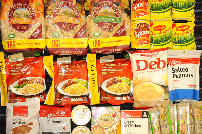 |
| Picture: On the "Great Central Road" I load the bike with about 12 additional kg of food and 24 liters of water. All in all, it makes then about 70 kilograms of luggage! Let's hope that the bike can withstand this burden on thosee bad roads. |
 |
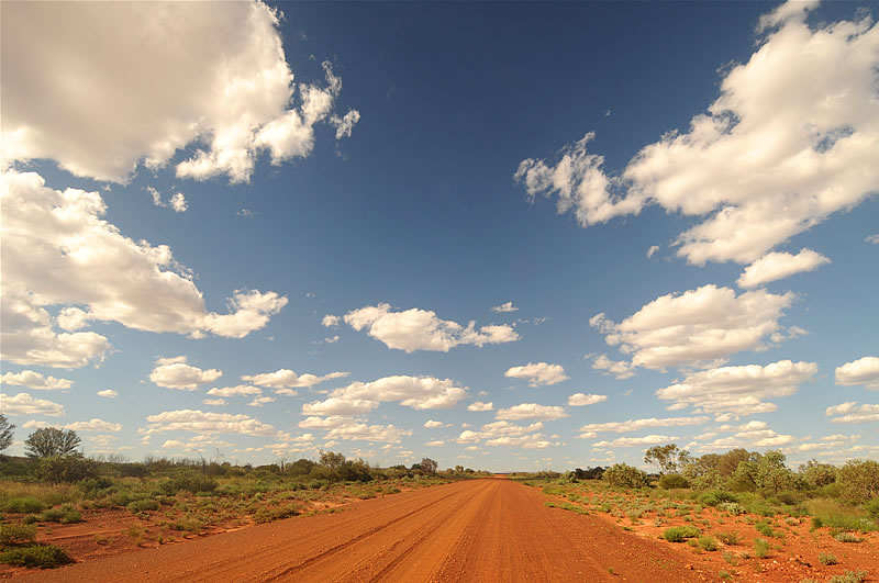
| Picture: Hundreds of miles away from civilization. Mostly the road is relatively well .... |
 |
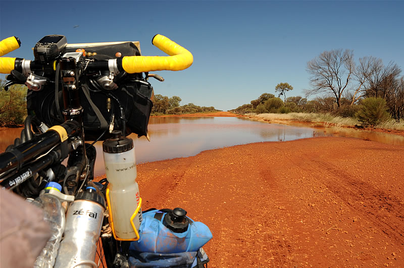
| Picture: ... but sometimes it is flooded an in very poor condition for dozens of kilometers. Sometimes I have to pushthe bike for shorter distances through the sand. |
 |
| Picture: Hundreds of kilometers through the vast bush. During the three days between Laverton and the Tjukayirla Roadhouse I have met a total of less than ten vehicles. Loneliness captured my mind and I began talking to myself. |
 |
| Picture: A multi-meter-long chain of hairy caterpillars across the street. |
 |
| Picture: Typical landscape in the Outback. |
 |
| Picture: After three days on the road, I reached the Tjukayirla Road House, the only point of supply for the next 250 km. |
 |
| Picture: Aboriginal art. |
 |
| Picture: After Tjukayirla Road House, the road was flooded in several places and impassable for vehicles without 4WD. Many truck drivers wait at the roadhouse for days to bring their cargo to western or northern Australia. |
 |
| Picture: Every day I drink 8 to 10 liters of water. Although I pack at the different supply points24 liters of water on the bike, which is enough for two or three days, I sometimes need some extra water. But w ith the the help of the water filter I can safely drink from all the waterholes beside the road. |
 |
| Picture: Alone in the vastness of the Australian outback. The "Great Central Road" is challenging to drive on a bike. For long stretches there is often just loose gravel or sand, which costs a lot of power. |
 |
 |
Picture: In the Roadhouse of Warburton, I met Eric and Marlis from Switzerland. They travel with their camper for several weeks across Australia. The friendly couple invited me to a delicious kangaroo steak with noodles and carrots. |
 |
| Picture: Between Warburton and Warakurna, the next village on my way to Uluru (Ayers Rock), the road was to drive a little better, and I could travel the 230 km within only two days. |
 |
| Picture: In the Australian Outback, I see often wild animals. Between Warburton and Warakurna I have seen a huge herd of camels. Almost every night in the tent I hear crying somewhere in the countryside dingos. But I still have not seen a single kangaroo ... |
 |
| Picture: After Warakurna, where I rested a day, I met two Frenchmen, Jean and Cyril, who drive with their Motrorrädern across Australia, then by ship to Vladivostok and finally drive from there back to France. |
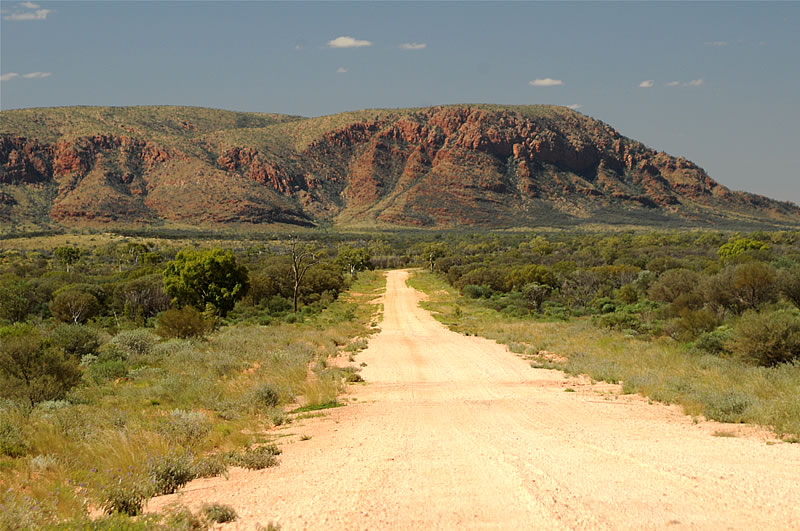 |
| Picture: Between Warakurna and Docker River, a small Aboriginal community on the border between Western Australia and Northern Territories, the landscape changed and the first time I saw mountains in Australian. |
 |
| Picture: To meet a larger tree in the Australian outback is already a remarkable event. |
 |
| Picture: Magical sunset at Docker River. |
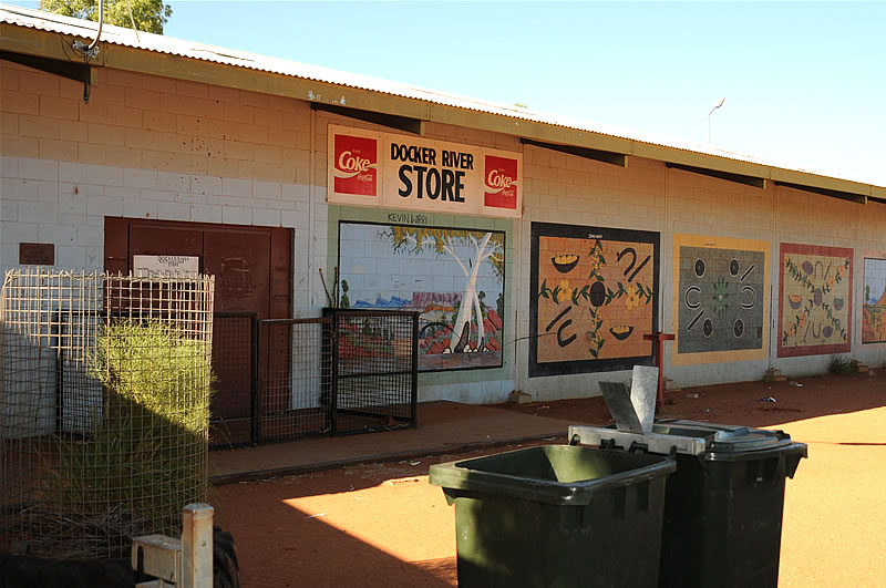 |
| Picture: In Docker River, there is a small grocery store. I wanted to get some supplies here , but the store is closed on Sundays. Bad luck. So I had no other choice than to endure the next three days to Yulara with two kilos of cereal and three slices of bread. |
 |
| Picture: Aboriginal children in Docker River. The Aborigoines populated Australia before about 40,000 to 50,000 years. With the arrival of the whites who occupied the water points and grazing grounds for their livestock,the Aborigines lost their livelihoods and started in their distress to chase the cattle and sheep of the whites, which led to violent conflicts. For about 150 years it came over and over again to bloody massacres. The number of Aboriginal people fell through the massacre and also by different disease from estimated 300,000 to 1 million (1800) to only 60,000 (1920). The Australian government officially carried trough several programs to eleminte the different tribes of the Aborigines. Genocide. Even today, many Aboriginal people are still deprived of their livelihoods and have not (yet) found in the modern society of the whites. They are mostly supported by the Australian government - which in turn leads to some resentment among the white population. |
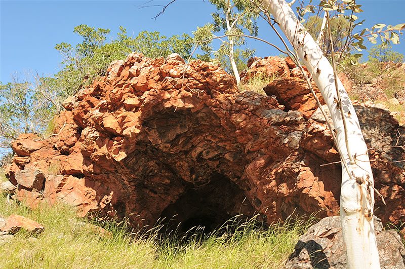 |
| Picture: In this cave about 40 km west of Docker River, Harold Lasseter has been holding out for a few days after his camels ran away with all stocks during an expedition through the Outback. Lasseter was a likely fraudulent gold seeker who pocketed with wild tales of huge gold deposits in the Outback vast amounts of investors'money. After the camels ran away on the trip to these alleged gold deposits, he started to walk to Mount Olga. Around 30 kilometers away from the cavehis body was found some time later. In his diary he noted: "What's a mountain of gold? I would give it away for a loaf of bread." |
 |
 |
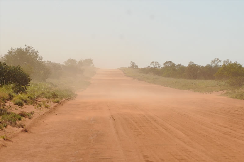
| Picture: In the two and a half days from Docker River to Kata Tjuta (Mount Olga), I experienced the worst-case of any bicycle tour. The headwind was so strong that he aroused the sand. A small dust storm. But even worse was the sande road. I had to push the bike often for several kilometers. Without daily meditation several times I probably would have gone crazy. |
 |
| Picture: Hundreds of kilometers away from civilization,an oncoming motorists gave me an apple. I was deeply impressed by the beautiful fruit. If someone l ooks and reads this now sitting in an office chair or in a cozy home, so he may think that it is just an apple, yes. But here in the Outback, where there are thousands of kilometers just burning sun, dust and dry grass, an apple is far more worth than the same weight in gold. |
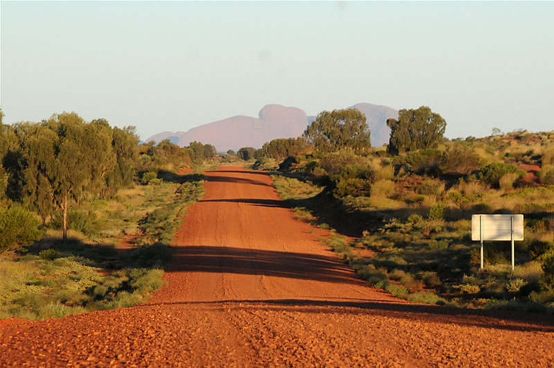 |
| Picture: When Kata Tjuta (Mount Olga) show up in the evening light on the horizon, I was delighted. The end of 1,100 km gravel and sand on the Great Central Road is in sight. Only 30 km to go! |
 |
| Picture: The next morning I reached after the last 30 km on the Great Central Road, where I had to push the bike a few times, the mountains of Kata Tjuta (Mount Olga), and thus the paved Lasseter Highway. I was probably at this very moment the happiest man on this beautiful planet... |
|
Next site: Central and Southern Australia |
|
|
|
|